Hellroaring and High Water

The first time I saw Ben Selznick, Brad Ludden, and Nick Turner hurling themselves down the astounding creeks and rivers of Montana on the big screen of a Teton Gravity Research movie, I said to myself, “I want to go there and do what those guys are doing.” It’s easy to follow the footsteps of someone else, yet when you venture into the unknown the experience is beyond words.
Two years ago I put in two hard weeks of guiding back-to-back teen canoe trips down the Yellowstone River. Every evening I'd settle down with a book to escape the mayhem of 12 teenagers and their constant chatter. Typically around the tenth page my mind began to wander and my thoughts were mostly about women or perhaps cold beer. Then I'd stare off into the snowcapped peaks of the Absaroka mountain range.
I pondered the possibilities of exploring these giant mountains first on foot, then by boat. I wanted to find the real Montana and mountains that big are practically required to have steep creeks galore, though I hadn't heard of a single run on this side of the range. I asked Jason Matthews, owner of River Source Outfitters in Livingston and a good friend at the raft company, what he knew about all the creeks that drain into the valley. He talked about the runs he'd explored by boat, horse, or just hiking around. I was intrigued but not all that inspired, because most of his beta yielded stories of log portages, shitty rocks, and maybe a good rapid here or there. Nothing that was itching to become an instant classic.
Then Matthews's eyebrows suddenly rose and he said, “Well, there is one run I've always wanted to do: Hellroaring creek, smack-dab in the middle of those beastly mountains.” He continued, “The only problem is, to get there you'd have to hike for at least a day over a mountain pass with fully loaded boats.” Jason has traveled deep into the wilderness for years on fall hunting trips and knows there's potential in the Absarokas, but it's hard to predict the summer flows when there's just a small trickle during late fall.
Two years later I found myself looking up at those same monstrous peaks as I took the last few steps toward exhaustion and the summit. My friends and I were going for it, unsure of the outcome, good or bad. All I knew was that my boat is really, really heavy when it's loaded for a three-day attempt at a first descent.
We made the summit, relaxed for some lunch, and enjoyed the scenery before the freezing wind and hail forced us to scramble down into the valley. The six-mile descent seemed far more inviting than the four miles we had just spent climbing straight up.
About seven hours later we stumbled toward the confluence of the middle and west forks of Hellroaring Creek, our planned put-in for the next day. We were soaking wet from the rain and rather pissed off by all the mosquitoes. We didn't bother to bring raincoats or bug spray, because every ounce counts when it's shoved into a creek boat you're about to carry over a mountain.
Luckily we spotted some smoke rising off in a distant meadow; we trudged closer and began to make out the shape of wall tents and horse corrals. A grizzled man wearing a wool sweater and a cowboy hat greeted us; his get-up was complete with a pistol at his side and a Skoal ring in his back pocket. “Now if this ain’t Montana, then I stumbled into the wrong saloon,” he said with a grin. This cowboy was in disbelief to see other people, let alone three guys carrying kayaks through the wilderness. He quickly invited us in for coffee and a fire, which made our bivy sacks a bit more inviting as we climbed into them just behind the horse corral. His pack-trip clients were just as curious about our presence as he’d been.
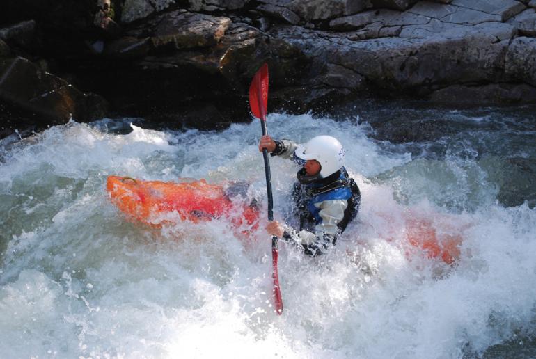
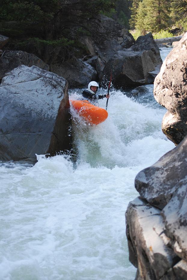
The next morning we put in and proceeded into the great unknown. At this point I didn't even care that we were kayaking; the trip had been amazing so far without it. Class V rapids were the furthest thing from my mind as we meandered through the gorgeous valley. A few hours later, the meander slowly started to pick up as we cruised through some class III and IV. Scouting carefully now, we began boofing our way through unknown granite gorges at what felt like the perfect flow. After running a series of two drops into an emerald pool, we pulled over for a granola bar and a chance to take it all in. There wasn't a single flutter of nervousness or anxiety as we peered downstream into the next horizon line. Nothing else mattered, because at that moment all of our efforts were worth every single footstep over that mountain pass.
We continued through the unknown water and steep, committing canyon walls. We spent most of the time going off on a limb and scouting as far as the next eddy. There were times when we proceeded into eddies using that ever-important gut feeling to provide confidence that the next scout would prove to be runnable. We boated though 11 miles of amazing scenery and class IV-V rapids roiling within three distinct gorges.
Eventually we hit the Yellowstone National Park boundary; we simply picked up our boats and walked proudly through the Park to avoid the bureaucratic mess of illegal boating within its boundaries.
Reading a guidebook or following another person’s tracks can be easy, but what most of us came here to do, according to Mark Twain, is to explore, dream, and discover. Two close friends and I found ourselves exploring an unknown river together this last summer for that very reason. We wanted to discover the real Montana, and throughout the journey we discovered a little bit about ourselves as well. But truthfully, the only dreaming we did was about cold beer and women.
Here's what you need to know about Hellroaring Creek:
Location
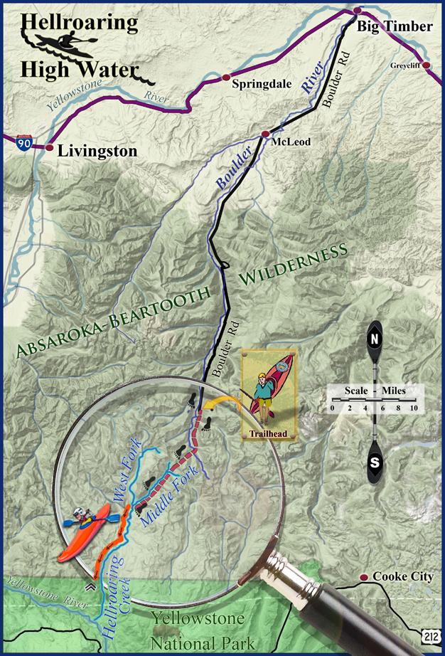
Put-in: From Big Timber drive south about 52 miles up the main Boulder road (Hwy 298) to Sheep Creek trailhead. A high-clearance 4WD vehicle and white-knuckle driving skills are required for the last five miles of dirt road (if you wanna call it a road).
Take-out: Hellroaring trailhead between Mammoth Hot Springs and Tower-Roosevelt inside Yellowstone National Park.
Distance (hike and boat)
From the Sheep Creek trailhead, hike 3.4 miles on Forest Service Trail 257 to the top of the pass. Then hike 6.4 miles on FST 12 down the middle fork to the confluence of the west fork in Bull Moose meadows. It's a total of 9.8 miles of relaxing backpacking over a mountain pass (aka, carrying a heavy plastic object through the woods with way too much shit in it).
Put-in at the confluence of the west and middle forks. You'll then boat roughly 11.5 miles to the Park boundary. Be aware that the boundary is situated directly between two ranger patrol cabins, so to avoid unnecessary court appearances, simply pick-up your boats and proudly hike them four miles to the road.
Rating
A class IV-V two- to three-day self-support mission.