Mount Blackmore
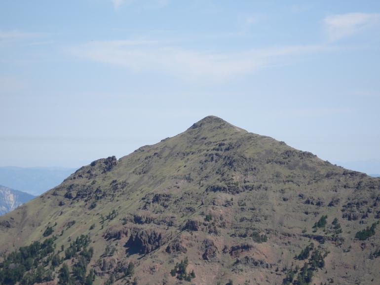
Gazing into the Madison Range from Bozeman, Montana, one is gratified by an excellent view of the jagged Spanish Peaks. However, there is only frustration when attempting to see beyond the high, forested foothills into the core of the Gallatin Range. The only exception to this rule is Mount Blackmore, which protrudes on the skyline over 10,000 feet in elevation. Ferdinand Hayden named the mountain after Mary Blackmore, wife of William Blackmore, English entrepreneur and friend who accompanied the Hayden Survey as guest. Mary Blackmore contracted pneumonia and died in Bozeman during the early summer of 1872.
The Hayden Survey returned to Fort Ellis in mid-September 1872 after a summer of exploration in the Yellowstone and Snake river highlands. Two groups of surveyors diverged from Hayden’s main party on September 14 to climb Mount Blackmore and explore the Gallatin Range south of Bozeman. They first attempted to use Bozeman Creek to access the mountain, but upon realizing their error and the difficulty of crossing high ridges toward Mount Blackmore, retraced their steps and entered “Middle Creek.” After two more days of travel through heavy timber and across boulder fields, they reached a scenic meadow, which they named “Palace Park” after the majestic monoliths of volcanic rock looming above.
From near the head of the park, Henry Gannett, Albert C. Peale, William Henry Holmes, William Henry Jackson, and possibly several others climbed west over a ridge into today’s Blackmore Creek and easily reached the summit of Mount Blackmore on September 18, 1872. Geologist Albert Peale wrote in his report for that day:
Mount Blackmore itself is a volcanic peak, and the nearness of the sedimentary rocks to the center of volcanic action, which lies to the south or southeast, has affected them to a great extent and thrown them into great confusion... The view from the summit of Mount Blackmore is grand in the extreme.
During the climb, Peale found “excellent specimens of Hyalite in globular concretions, as clear as glass, coating the rocks and making them look as though coated with ice.” The presence of this mineral, known today as hyaline opal, would later lead P. C. Waite to rename the valley “Hyalite Canyon.” The name “Mount Blackmore” was included on the Three Forks quadrangle in 1886.
Ascent: South 19th Street in Bozeman, Montana makes a 90-degree turn to the west as it approaches the mountains. One mile later, the paved Hyalite Canyon Road turns south and winds for over 10 miles to Hyalite Reservoir. Just before Hyalite Canyon Road crosses the dam, turn right and park at the Blackmore picnic area, boat launch, and trailhead. To access Hyalite Canyon from Highway 191 in Gallatin Canyon, turn east onto Cottonwood Road just south of Gallatin Gateway, Montana. Follow this circuitous dirt road for nearly five miles to the mouth of Cottonwood Creek and continue for an additional two miles to a right turn. After one mile, turn south onto Hyalite Canyon Road.
From the trailhead, follow the well-worn Blackmore trail (Forest Trail #423) as it switchbacks up the broad ridge east of Blackmore Creek. The trail drops to Blackmore Lake, then climbs steadily along the upper creek through some switchbacks to a scenic meadow below a final steep headwall. The trail climbs this headwall in several long switchbacks to gain the saddle between Elephant Mountain and Mount Blackmore. From the saddle, it follows the southeast ridge of Mount Blackmore easily to the summit. A quicker and more direct route to the summit departs the trail in the meadow below the final headwall. From there, a wide grassy ramp leads gradually northwest to the summit. With its proximity to Bozeman, it is no surprise that Mount Blackmore has become a favorite peak for mountain runners, who can make the round trip in under two hours during their best days.
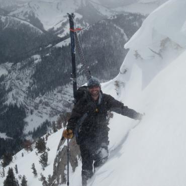
Such quick access to Mount Blackmore and neighboring Elephant Mountain has lured Bozemanites on foot and skis for decades. A bold and skilled generation of ski mountaineers, fostered by Tom Jungst and Jim Conway, sprouted from the Montana State University ski team in the mid-1970s. When not training or racing, this pair honed their steep skiing in the limestone chutes of the northern Bridger Range, along with skiing legends such as Emily Gladstone, Doug Coombs, Steve Jackson, Scot Schmidt, Emil Tanner, Whit Thurlow, and others. In the spring, snow in the Bridger Range melts early, so Jungst and Conway would trek into the Crazies, Tobacco Roots, Madison Range, or northern Gallatin Range where north facing couloirs and snowfields provide good skiing much later into the season. Unemployed during the spring of 1978, Jungst and Conway made their first of many outings to the head of Blackmore Creek with a ski descent of a highly visible couloir on the northwest face of Elephant Mountain that they dubbed “The Laser.” This 50-degree test piece has at least two doglegs and two narrow crux sections in about 1,200 feet of skiing into Blackmore Creek. On another trip that spring, they skied the north face of Mount Blackmore, where a moderate Y-shaped couloir rises from a vast bowl before splitting around the summit knob.
In the spring of 1980, Jungst and Conway introduced Emily Gladstone, Emil Tanner, and a visually-impaired ski team outcast named Doug Coombs to ski mountaineering in the Blackmore basin with a descent of The Laser, which Coombs later renamed “The Ribbon.” Even as Jungst and Conway traveled the world as ski movie models through the 1980s and 90s, they returned often with Coombs, Gladstone, and Tanner to repeat descents of The Ribbon and Blackmore, sometimes in August or even September. During one winter outing in 1983, Jungst, Conway, and Coombs skied the north face of Blackmore in frigid temps and white-out conditions. A few weeks later, Jungst and Coombs skied The Ribbon. To Jungst’s astonishment, Coombs “aced the crux after I had to stop and hop through. I will never forget that! He came through like it was a GS run. There was no runout and he pulled it off!” Little did anyone know that Coombs, also a veteran of chute skiing in the northern Bridger Range, would later gain world renown for his skiing prowess. Tanner intimated, “It was always Doug among us who could thread the finest lines between rock and tree, and somehow come out with clean bases… and with greater touch than it ever had before.”
During the 1990s, Alex Lowe and Hans Saari pushed the envelope even farther on Elephant Mountain. This pair discovered “a sneaky couloir” that connects with The Ribbon about halfway down. Often used as the descent gully for an ice pillar just east of The Ribbon known as “The Tusk,” it is extremely narrow and steep. Saari wrote, “This is where I learned how to hop backwards down narrow stuff. Probably not a line I would really recommend to my friends, but a fun little puzzle.” Saari and Lowe also reported a ski descent of the “Hellmouth Couloir,” which is a fantastic north-facing gash on Peak 10,031 south of Mount Blackmore at the head of South Cottonwood Creek. The standard ski lines off Mount Blackmore include the southeast ramp, which rolls over moderate terrain into the head of Blackmore Creek, and the east face, which sports several chutes above a large bowl.
Ascent
Blackmore Creek parking elevation: 6,720 feet
Elevation gain: 3,434 feet
Distance: 5 miles
Overall grade by southeast ridge: I Class 1
Estimated ascent time: 1.5 to 4 hours
Maps: Mount Blackmore, Fridley Peak
Thomas Turiano lives in Jackson, Wyoming with his wife and daughter, where he works with Exum Mountain Guides and Jackson Hole Alpine Guides. His first book, Teton Skiing: A History and Guide, was published in 1995. Select Peaks of Greater Yellowstone, from which this article was excerpted, was published in December 2003.