Beat This

Backpacking the Beartooth's Beaten Path.
Think a beaten path is for newbies and the unimaginative? Think again and meet the Beaten Path of Yellowstone country. “It’s a popular trail because it’s a beautiful trail,” says the USFS officer during a pre-hike visit to the Beartooth Ranger District in Red Lodge. Although, he quickly reminds me, “popular” in a southwest Montana Wilderness Area is a far cry from the intense crowds visiting the region’s national parks.
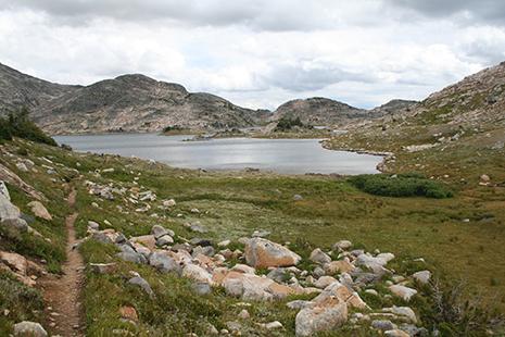
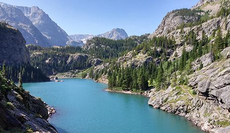
Though hiking the Beaten Path requires a shuttle, the route earns its popularity by providing quick access to breathtaking alpine landscapes. Both trailends climb, sometimes strenuously, upward through opposing glacial valleys, and meet on a granite ridge roughly five miles south of 12,799-foot Granite Peak, Montana’s highest point. An abundance of wildflowers bloom at higher altitudes in late summer, but watch for afternoon thunderstorms. Pack your fly rod as both water and trout are abundant in this stream-, lake-, and waterfall-riddled wilderness.
Trip stats
Distance: 25.8 miles | Time: 3 days | Difficulty: moderate, with strenuous sections
Turn-by-turn
From Clarks Fork trailhead: Begin on the Flume Trail and almost immediately cross the Clarks Fork, then continue for 0.4 miles. Turn right onto FS#3 (Clarks Fork Trail). This 0.4-mile section is a 4WD road that the trail parallels; may be mucky. 4WD road turns left, stay straight on FS#3 for 2.0 miles to intersection and A-B Wilderness boundary sign. Bear left onto FS#567 (Russell Creek trail); its name changes to the East Rosebud trail (FS#15) at the ridgeline and ends at East Rosebud Lake in Alpine (15 miles SW of Roscoe).
Campsite 1
Russell Lake (6.2 miles). Several great campsites are located between the shore and the trail, prior to the Mariane Lake trail intersection. If you visit early as the snow is disappearing and water temps are cool, cast your fly rod into the lake for rainbow and brook trout, especially at the stream inlets along the northeast lake edge.
Campsite 2
Twin Outlets Lake (13.8 miles). Getting to Campsite 2 is a must if you want a campfire, as it is just beyond the fire ban area that begins at the ridge near Fossil Lake and extends east to upper Twin Outlets Lake (As always, check with local angencies for up-to-date fire and travel regulations). There are several photogenic campsites on the lake’s lower tail, which feeds into Impasse Falls below.
Bear in mind
This is grizzly country. Carry bear spray, know how to use it, and keep it accessible at all times. Practice your bear bag-hanging skills before setting out or pack a bear can. Keep both you and your food safe.
Details
Trailhead: (45.018602, -109.872878); 3 miles east of Cooke City on US 212 / Beartooth National Scenic Byway, across from Chief Joseph Campground
Shuttle: Red Lodge Taxi (redlodgetaxi.com) operates a shuttle for a fee. Contact the Red Lodge Chamber of Commerce for additional suggestions.
Season: July to November
Permits: None
Waterproof map: Beartooth Publishing ($12)
Contact: Beartooth Ranger District, Custer Gallatin NF, (406) 446-2103