Summer's Finale
Three chest-thumping hikes to finish your summer
Pick one:
A) Your summer has consisted of eating hamburgers and floating the Lower Madison, and you want at least one hard-won accomplishment before fall rolls around.*
B) You've spent every weekend bagging peaks and hauling a 60-pound pack around the backcountry. A long, classic Montana dayhike is the cherry on top of your lung-busting summer.
Whoever you are, set aside a full day in the last few weeks of summer to try one (or all) of these season-culminating hikes. None of these trails require technical skills or a vehicle shuttle, and each can be completed in a day—albeit a long one. Trailheads are all within two hours of Bozeman, and the scenery / bragging rights can't be beat. Don’t forget water, a map, snacks, and layers. Keep your bear spray accessible—we saw grizzlies or fresh scat on every trail. Always let someone know where you’re going and when you plan to be back.
*If you fall into category A, allow yourself more time to make the climbs. Your lungs and quads will thank you.
Pine Creek Lake
Distance: 10 miles (out-and-back)
Elevation gain: 3,400 feet
Best Feature: Jaw-dropping alpine lake fairy tale land of dreams
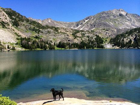
The Hike: This is the most popular hike of the three, but don't let that take away from the accomplishment. The five-mile trek to the lake gains 3,400 feet, and the majority of the climb happens after the first mile. The trail starts off deceivingly mellow, and you’ll likely be packed in with hordes of hikers heading to Pine Creek Falls. At one mile, continue past the falls and climb a series of steep switchbacks through dense forest. You’ll see cascades, streams, and vibrant new undergrowth making a comeback after recent fires. The crowd has certainly thinned by this point, and as your lungs threaten to collapse, you’ll realize why. Right when your wheezing starts to scare the wildlife, the trail pops out in a massive bowl, with a panoramic view of Paradise Valley. Three more of these openings will get you to the lake. The trail curves around the perimeter of towering granite walls with plunging waterfalls, and most will be too distracted by the surroundings to be tired. Jewell Lake appears after the trail tops the cliffs, and Pine Creek Lake is just out of sight from here. The stunning, freezing alpine lake is so worth the hike, and more than one out-of-breath hiker said, “This… is... my favorite… hike in… Montana.” If you still have air in your lungs, get rid of it by diving into the lake. Shrieks and frantic splashing to follow.
Beta: From Bozeman, head east on I-90, take exit 333, then go south on Hwy. 89. After about 10 minutes, go left on Pine Creek Road, then take a right on East River Road. Take a left on Luccock Park Road to a large parking area. Cross the bridge at Pine Creek Falls to continue to Pine Creek Lake. The trail is well-maintained the whole way.
Emigrant Peak
Distance: 6 miles (out-and-back)
Elevation gain: 4,687 feet
Best Feature: Summiting a prominent peak on the western side of the Absarokas. Fear of electrocution.
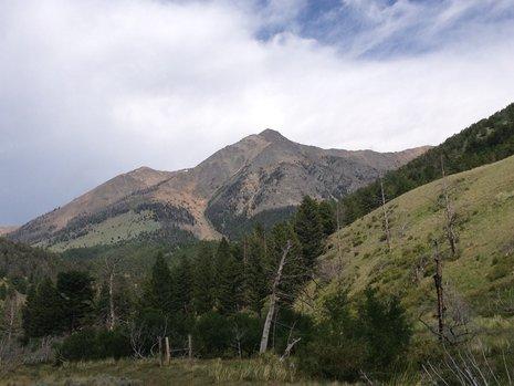
The Hike: At 10,921 feet, this is one of the most prominent mountains in Paradise Valley, and a great one to check off the ol’ peak-bagging list. It starts at the Gold Prize Creek trailhead, which can be tough to locate, so do your research beforehand and get an early start to avoid afternoon lightning storms on the summit. Initially, the trail is well-defined and maniacally steep as it climbs through a field, along a fenceline, and onto the Northwest Ridge. Then it pretty much vanishes—just keep climbing. The path turns to scree above treeline, and the footing gets pretty loose. When I climbed Emigrant with friends, a thunderstorm hit as we reached the second false summit, and I panicked and slid/tumbled down the scree back into the trees while my companions booked it to the top amid static electricity and crackling lightning.
Beta: From Bozeman, head east on I-90, take exit 333, and head south on Hwy. 89 to Pine Creek Road. Turn left onto Pine Creek Road and then right onto East River Road. Continue to Sixmile Creek Road, heading towards Dailey Lake and Sixmile Creek. Follow this gravel road for four miles to a little parking lot. Head into the Sixmile Creek drainage through the gate, following the road for about a mile, then turn left off on a faint singletrack to the Gold Prize Creek trailhead. The trail starts out clearly, then gets fainter and fainter the as you ascend the peak. Stick to the Northwest Ridge spine and it’s tough to get lost.
Sky Rim Trail
Distance: 21 miles (loop)
Elevation gain: 3,400 feet from trailhead to high point, with many smaller, steep ascents scattered throughout.
Best feature: Endless views... and so many mountain goats.
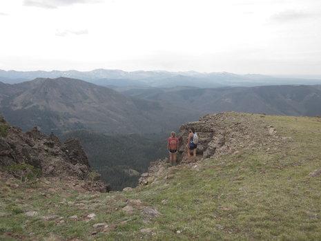
The Hike: This spectacular ridgeline trail follows the northwest edge of Yellowstone Park along its border with the Gallatin National Forest. On this hike, expect mountain goats, hundred-mile vistas, and solitude. I've always thought ridgelines make for easy hiking: get to the ridgeline, enjoy a flat traverse with epic views, then trot down to the car. Sky Rim shatters those delusions with a series of steep climbs and descents that make you work for the reward. The trail disappears in several grassy places—just get to a high point and scan for trail markers. Sky Rim is more commonly hiked as a two-night backpacking trip, but you’ve totally got this.
Beta: From Bozeman, take Hwy. 191 south to the Daly Creek trailhead between mileposts 30 and 31. The trailhead is obvious, but there are several junctions along the trail, and it’s easy to get confused. Start at Daly Creek trailhead, then turn left at the Black Butte cutoff trail. Turn right at the Teepee Creek junction, and look for Sky Rim junction signs about 6 miles in. After 11 miles, turn right at Black Butte junction, then right again at the next Black Butte sign. The Daly Creek signs will point you back to your vehicle. This is the route I chose. There are several options in the area, so I highly recommend referencing Bill Schneider’s Hiking Yellowstone National Park, or a similar guide with a map and trail junction details.
There you have it. Whether you hike one of the trails or do all three, don't let summer end without adding something to your "I Live in Montana and I'm a Badass" repetoire.

