Review: AspectAvy App


Nowadays, there are lots of backcountry-navigation apps to choose from, and most mapping software has become highly specialized to each different outdoor activity. Which makes sense—an angler doesn’t need all the features that an off-roader would, nor would a climber need the same tools as a hunter. It’s nice to see software pared down and streamlined for specific activities.
Enter AspectAvy: the next evolution in backcountry-skiing navigation. This app brings a whole new set of features that integrate the daily avalanche forecasts directly into your map, making it easy to find the information you’re looking for to help make good decisions in the backcountry. The app even gives terrain recommendations based on snow stability. Here’s how it works.
Each regional avalanche center’s forecast zones are overlayed onto the topo map in AspectAvy. The zones are color-coded by danger level, just like you'd see on an avalanche center’s website or in a daily avalanche bulletin. For example, if the Bridgers were forecasted as “low” danger, that area would be shaded green; if the northern Gallatins were “moderate," they would be yellow. Any zones with a “considerable” or higher rating are colored red.
So with AspectAvy, you can’t miss the forecast. When you click on a forecast zone, a window pops up on your screen with a general terrain recommendation, along with a list of the problem types for that zone; e.g., “wind slab,” “persistent slab,” etc. The window also has a link to the regional avalanche center’s website so you can read the full forecast. You’ll need cell service to access this, so best to utilize that feature before leaving the house.
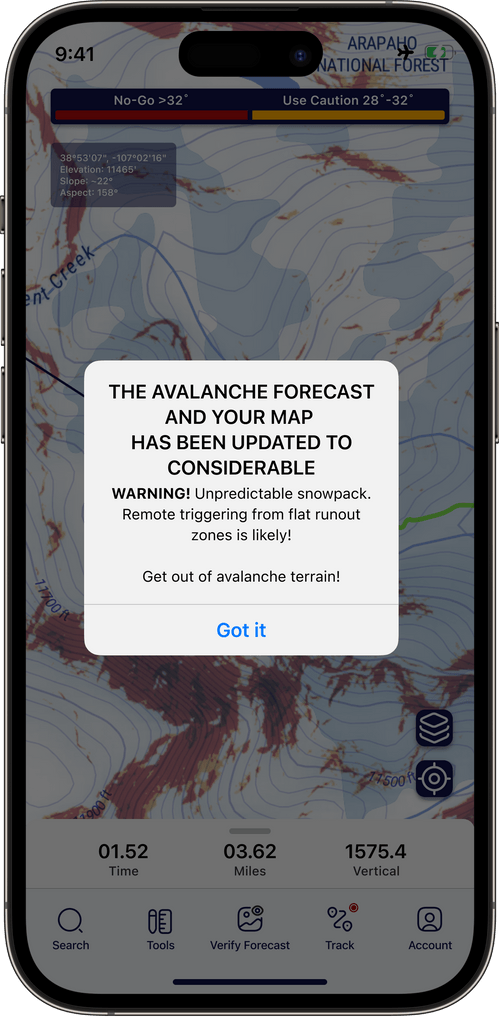
Having an avalanche-forecast overlay on your map is very convenient, but AspectAvy takes it one step further with dynamic slope-angle shading. This feature looks similar to that of other backcountry apps, but differs in that the shading varies depending on the avalanche danger for each given day.
The dynamic slope-angle shading has three levels: white (safe), yellow (caution), and red (avoid). The shading is based on the general “danger” level of the day’s avalanche forecast, but also takes the forecasted problem type into consideration. As you can see in the screenshots below, the slope-angle shading varies quite drastically based on the avalanche-danger rating.

Dynamic slope-angle shading with "low" danger

Dynamic slope-angle shading with "moderate" danger

Dynamic slope-angle shading with "considerable" danger
Of course, these slope-angle ranges are general recommendations and are by no means an absolute measure of safety. But the shading gives a much clearer picture of how to stay safe in the backcountry by avoiding certain terrain, and the ranges coincide with terrain choices we’d expect to see from an experienced backcountry skier who’s playing it safe. So if you follow AspectAvy’s terrain recommendations, you’re going to be in a pretty good spot. Just be sure to always discuss your decisions as a group before dropping in.
The app also has a feature that allows you to input your own snow-stability observations—such as shooting cracks, rapid warming, and "whumphs"—which will subsequently update the map.
Another neat feature from AspectAvy is the inclusion of safety checklists. There’s one checklist for the trailhead, and another for the top of the run.
In addition to these novel avalanche-safety features, AspectAvy has a suite of standard backcountry mapping tools such as GPS tracking and offline maps. What's different is that the interface is very streamlined and uncomplicated—a welcome change from many existing apps that take a “do-it-all” approach.
If you’re looking for the next greatest software in backcountry-ski navigation, give AspectAvy a look. Available at aspectavy.com (link to App Store); $50 per year.