Hidden Assets
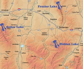
Everybody knows about Hyalite Reservoir and Fairy Lake, Bozeman area's "drive-up" lakes. But if you're willing to hike a little, you can escape the crowds and revel in the sunny solitude of these "secret" lakes nearby.
Frazier and Ainger Lakes
A small, high lake in the Bridgers (8,100' elevation), Frazier generally drains out when the previous winter's snowpack melts away. Because of this, late June is the best time to visit, though the view is top-notch all season.
The most popular route to Frazier Lake is Shafthouse Trail #540, which begins at Fairy Lake Road, about a mile short of the Fairy Lake campground. There isn't an established parking area at the trailhead, but the trail sign is visible enough. The fairly easy hike goes steadily uphill through meadows with great views and abundant wildflowers.
There is no marked trail to the saddle. After the first mile, it's close by to the left (roughly west), and you'll have to leave the Shafthouse Trail and pick a route over the meadow to reach the saddle. By this time, you'll have a fine view of Sacagawea and Hardscrabble Peaks, and Fairy Lake will seem to be a tiny blue pond in the distance.
If the lake looks low or dry from the saddle, consider continuing west and following the ridge, which offers some great high-mountain scenery. If you're equipped for a more strenuous climb, proceed to the highest point, a series of unnamed peaks at the spine of the Bridger Range. If you do want to visit Frazier Lake—and enough of the snowpack has receded it's a fairly easy scramble down the slope from the ridge of the saddle. A hiking stick is helpful here, because the soil is loose and rocky. This hike is enough of a deterrent for most; chances are 50-50 you'll have the lake to yourself.
There are also a couple of ways to access Frazier Lake by way of Frazier Creek. One way is to find the unmarked turnoff to USFS Road 75, which is on the north side of the Fairy Lake road, about four miles from Highway 86. Road 75 is gated after about a quarter mile and is now closed to motor vehicle traffic, but there is sufficient parking for a couple of vehicles by the gate and it's an easy four-mile bike ride north to Frazier Creek. An old spur road just south of the creek heads west and allows bikers to ditch their rides a little farther upstream.
The second way to get to USFS Road 75 is via the east Shafthouse trailhead. If you plan to hike instead of ride to Frazier Creek, you may find this route a little shorter. Get to the trailhead by following Highway 86 about 3.5 miles north of the Fairy Lake turnoff, then turning west at Seitz Road and following it about 2.5 miles to the trailhead. Beware: the trail crosses private land for the first mile, then runs southwest through the Gallatin National Forest for another mile before it intersects with Road 75. At the road, leave the trail and follow the road north a half-mile until it crosses Frazier Creek.
There is no bike trail at Frazier Creek; in fact, there's no "official" trail of any kind, though there's an obvious track left by pack and game animals, which makes it an easy hike. Ainger Lake-an oversized pond, actually-is about two miles upstream from where USFS Road 75 intersects Frazier Creek.
From this point, the trail fades out and following the creek upstream is your best bet. About a half mile from Ainger Lake, you can find the head of Frazier Creek, a spring that bursts out of the rocks above and tumbles down the slope. This spring drains Frazier Lake dry once the meltwater disappears in July, so this is a much more rewarding hike in the early season when there's still some snowpack in the Bridgers. The base of the waterfall is not hard to reach unless it's early in the season; in that case, hiking up a snow bank may be the only way to get close.
A short scramble up the slope heading northwest from the waterfall will find the grateful and weary hiker arriving at the east shore of Frazier Lake.
Hidden Lakes
The Hidden Lakes Trail is south of Bozeman and east of Big Sky. Access it via Portal Creek Road, where the trail leads to a small chain of lakes at the base of a ridge in the Gallatin Range. The largest and highest lake is the "official" Hidden Lake, at 9,025 feet—about 850 feet above the trailhead and about three miles in. These lakes are not stocked, but there are golden trout in at least a couple of them.
To get to Hidden Lakes via US Highway 191, look for the Portal Creek Road 984 sign between mileposts 53 and 54. The sign facing the southbound lane is much more obvious than the one facing traffic coming north from Big Sky. The exit is on the east side.
The Hidden Lakes trailhead is about six miles from the highway. About halfway in, the road forks and a Forest Service sign indicates the correct route to the Hidden Lakes trailhead. Trail #66 is a pretty straightforward hike—steeper for the first mile, then giving way to a more comfortable mix of uphill and downhill. The only tricky part is where the trail forks, about a mile and a half from the trailhead. There is no sign at the fork. The left fork is the continuation of Trail #66, and leads the hiker to a ridge ending on the south side of the highest lake, but this route bypasses the other lakes. The right fork, Trail #179, is probably the one you want to follow, as it leads directly to the lower "Hidden Lakes" in the chain. From there you can follow the trail to the higher lakes and finally to the "official" Hidden Lake, the highest lake in the chain.
Hidden Lake is a beautiful blue lake in an equally beautiful setting: a bowl enclosed on the south by a high rocky ridge and on the north by spruce. Casual climbers (or serious hikers) can hike to the west side of the lake and up the ridge, about 700 feet above the lake. It's a steep slope, but not dangerous if the weather is clear and you're careful. Those who make the effort are rewarded at the top with clear views of the Gallatin Range, the Spanish Peaks, and the Madison Range. Many of the evergreens on this ridge are twisted and bent in interesting shapes by the high winds. Depending upon the time of your visit, there may be plenty of wildflowers as well.
There are no developed camping facilities at Hidden Lakes, but good spots to pitch a tent abound. The ridge blocks the nighttime glare from Big Sky, so overnighters will have plenty of stars to gaze at. An added bonus is the peace and quiet. The dust and noise of a busy campground road is not part of the Hidden Lakes experience. On a "busy" evening, campers may see the smoke of one or two other campfires in the distance.
Sailor Lake
Nestled deep in the Tobacco Roots are a few other out-of-the way lakes, including Sailor Lake, Brannan Lakes, and Globe Lake. To reach the mountains, get onto Highway 359 from the north via Interstate 90 exit #256 at Cardwell or from the south via US 287 near Harrison. The South Boulder road exits MT 359 on the west and then twists and turns past farms and ranches before following the South Boulder River southwest into the canyon.
At 16.2 miles in, the road forks, giving travelers a choice to go left to Bismark Reservoir and the Louise Lake trailhead, or right to go to Sailor Lake. The right fork is a two-track road that is obviously more primitive and less traveled. This last section of the road is best navigated by high-clearance 4WD vehicles, or better yet, ATVs; it no longer appears to be maintained by the Forest Service. The road dead-ends at a small campground and the Trail #167 trailhead, 18.7 miles from MT 359.
This trailhead offers relatively easy access to Sailor Lake and two smaller, higher lakes (Globe Lake and Brannan Lake) that drain into it. Sailor Lake is the first stop on Trail #167, a pleasant uphill hike of about half a mile. Be warned, however: the mosquito population is higher than average on this trail, more on par with trails along the lower Yellowstone River bottom. Bring bug juice, and lots of it.
The trail follows the south shore of Sailor Lake, a scenic and uncrowded spot. Toward the east side of the lake, the trail forks east and north. The north trail heads uphill to Brannan Lakes, nestled in a bowl at the base of an unnamed peak, and offers a great panoramic view of Sailor Lake and the surrounding peaks of the Tobacco Roots. The east fork is a shorter, quarter-mile hike that ends at Globe Lake. Globe Lake is a little smaller than Sailor Lake and lacks an open view of the mountains, but it is another beautiful and secluded spot.