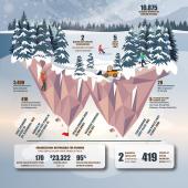
By the Numbers: Spring on the Gallatin


The Gallatin River is our backyard playground—we fish it, paddle it, swim it, hunt it, meander it. Come spring, it’s more dynamic than ever, waking from a season-long slumber, roaring to life once again. Here are some facts and figures about Bozeman’s beloved local waterway.
Etymology: Albert Gallatin, Secretary of the Treasury during Lewis & Clark expedition (and longest-serving Treasury Secretary in U.S. history)
Headwaters: Yellowstone National Park, northwest corner
Terminus: Three Forks, MT (headwaters of the Missouri River)
Length: 120 miles
Descent: 2,500 vertical feet
Ordinary Rating: Class I-II
Whitewater Rating: Class III-IV, through Gallatin Canyon during runoff
Highest peak runoff: 9,160 cfs – June 2, 1997
Lowest peak runoff: 1,740 cfs – May 8, 1934
Average April streamflow: 503 cfs
Average May streamflow: 1,810 cfs
Average June streamflow: 2,920 cfs
June 7: highest daily average streamflow, 3,340 cfs
Risk Factor: The Gallatin can be deadly any time of year, but spring is particularly dangerous. The water is high, cold, and full of debris. The most recent death occurred at peak runoff in 2015—don’t underestimate our backyard playground.
All readings taken at Gallatin Gateway
cfs = cubic feet per second