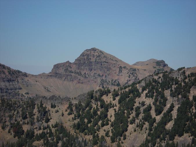
Summer Summits in Hyalite
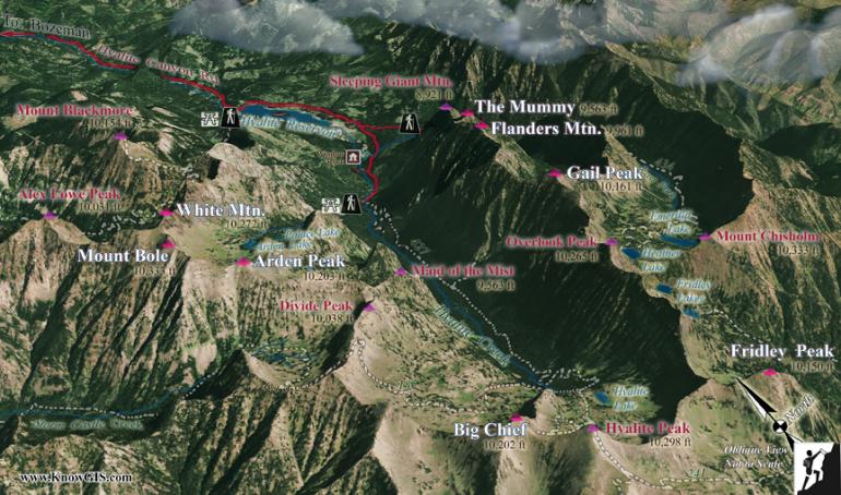
Over the past several years, my friend Ted Border and I attempted to climb all of the named peaks in the Hyalite range. After our successful ascent of Fridley Peak in July of 2005, we felt like we had accomplished our goal. We soon discovered, however, that our enjoyable mission was far from over. There were more 'unofficially' named peaks yet to be climbed.
I've used the Climber's Guide to Montana by Pat Caffrey for over two decades to find places to go and routes to take. After climbing Fridley, I took a closer look at the guide to see if we missed any mountains in the Hyalites. I was excited to find four mountains I had never heard of: Gail Peak, Big Chief Mountain, Arden Peak, and White Mountain. I thought it was strange that I had never heard of them before, and there was a good reason: all of these names were unofficial, according to the Gallatin National Forest.
It didn't make any difference to us that they were unofficial names. We were just excited to have more spectacular places to visit. And we've since climbed them all. What follows are the routes we took to get to the top of each, as well as routes for Mount Bole, Fridley Peak, Flanders Mountain, and the Mummy: four mountains that may not be as popular as Mount Blackmore or Hyalite Peak, but still make for fun and adventurous climbs.
Getting Started
The trailheads for Gail Peak, Big Chief Mountain, and Fridley Peak are close to Hyalite Reservoir. Drive along the east side of the lake for just under two miles until you reach a fork in the road. The road to the left takes you another two miles to the East Hyalite trailhead. This is the beginning of the Gail Peak climb. To climb Big Chief or Fridley, continue south when you reach the fork in the road to the very popular Hyalite trailhead. This trail will lead you past five stunning waterfalls. The Arden Peak, Mount Bole, and White Mountain point of departure is in the Storm Castle Creek (Formerly Squaw Creek) drainage. The Mummy and Flanders Mountain hike begins about 1.75 miles down the East Hyalite trailhead road.
Gail Peak: 10,161 feet (Unofficial)
Approximate Time to the Top: 2.5 to 3 hours
Latitude and Longitude: N 45 25.30' W 110 56.43
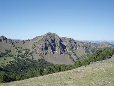
The Gail Peak hike begins at the East Hyalite trailhead, trail #434. Just before reaching Emerald Lake, after a trek of about four miles, turn west and head toward a bowl-shaped area between two peaks. It takes a little over an hour to reach the summit once you leave the trail. The mountain itself appears to be just a ridgeline. Once you have reached the bowl, the route to the ridge is easy to see. When you have gained the ridge, head north for a short distance to the real summit. This centrally located peak will give you a fantastic view of the entire range.
Big Chief: 10,202 feet (Unofficial)
Approximate Time to the Top: 3.5 to 4 hours
Latitude and Longitude: N 45 23.040 W 110 58.023
If you love a good trail, then Big Chief Mountain is for you. The Big Chief hike begins at the Hyalite trailhead, trail #427 (Grotto Falls), and follows almost the exact route as Hyalite Peak. Once you've gone the five miles to Hyalite Lake, on the west you'll have a view of the northwest-southeast ridgeline that Hyalite Peak and Big Chief Mountain share. Climb to the saddle between the peaks, then head northwest to the top of Big Chief. If you need a bit more of a workout, climb Hyalite Peak as well.
Arden Peak: 10,203 feet (Unofficial)
Approximate Time to the Top: 3 to 3.5 hours
Latitude and Longitude: N 45 24.737' W 110 59.367'
The climbs for Arden Peak, Mount Bole, and White Mountain all begin from the same spot: the Storm Castle trailhead, trail #185. The turn-off for the trailhead is about 15 miles south of Four Corners on Highway 191. Once you've crossed the bridge over the Gallatin River, drive 11 miles east to the trailhead. Follow the trail for about four miles to the top of a series of switchbacks. Not long after reaching the top of the switchbacks, you will arrive at a meadow just west of Divide Peak. This is the beginning of the scramble for all three mountains. The ridgeline directly to the south is where you'll find Arden Peak. Like Gail Peak, Arden's location is somewhat of a mystery because it resembles a ridgeline when viewed from the south. After climbing 1,500 vertical feet, however, the top becomes more evident.
Mount Bole (Boles Peak):10,328 feet (Official)
Time to the Top of Mount Bole: 3 to 4 hours
Latitude and Longitude: N 45 24.965' W 110 59.892'
White Mountain (Liberty Cap): 10,272 feet (Official)
Time to the Top of White Mountain: 4 to 5 hours
Latitude and Longitude: N 45 25.391' W 110 59.889'
Both peaks are included here because you must climb nearly to the top of Mount Bole to get to White Mountain. The starting point for these climbs is once again the meadow to the north of Arden Peak. The climb begins in a fashion similar to the Arden Peak ascent; however, instead of climbing straight up to the ridge, gradually angle northwest toward Mount Bole. Near the ridge, a false summit appears that will give you a great view of both Mount Bole and White Mountain. After a bit of scrambling, you'll be on top of the highest peak in the Hyalites (tied with Mount Chisholm).
At this point, you have three options: go down the way you came up, go on to White Mountain, or descend the drainage directly west of Mount Bole. If you decide to go down, I highly recommend the west drainage. There's a small amount of bushwhacking and a couple of waterfalls to scramble around, but this route is shorter and reduces the wear and tear on your body.
If you decide to go to White Mountain, go with care. The route is obvious: head north on the ridge between Bole and White. But the narrow ridgeline near White Mountain does have some exposure that you should navigate with caution. The final approach to the summit heads around to the east side of the peak.
The Mummy: 9,354 feet (Official)
Time to the Top: 2 to 3 hours
Latitude and Longitude: N 45 26.798' W 110 56.552'
Flanders Mountain: 9,862 feet (Official)
Time to the Top: 3 to 4 hours
Latitude and Longitude: N 45 26.314' W 110 56.981'
I've combined these peaks because they share a ridgeline. Even though we climbed the mountains on different days, you could do both during the same trip. Once you reach the reservoir, both mountains tower to the south on the east side of the canyon. Finding the starting point of this hike can be a little difficult, because there isn't an official trailhead. After driving 1.75 miles toward the East Fork trailhead, you'll see a canyon heading south on the east side of Sleeping Giant Mountain. The GPS coordinate 110 55.651' W, 45 27.640' N will give you an idea of where to begin.
At this point, cross the East Fork of Hyalite Creek and make your way south into the canyon. There's a crude trail along Flanders Creek that leads about 1.75 miles to Flanders Lake, but you'll probably have to do some bushwhacking. Once you reach the lake, head northwest up to the ridge, where you'll find the Mummy. If you decide to continue on, the route to Flanders Mountain is fairly obvious. Follow the ridge southwest from the Mummy where it gradually turns south, leading to the top of Flanders. The views of the Hyalite Range from the top Flanders are truly awe-inspiring.
Fridley Peak: 10,082 feet (Official)
Approximate Time to the Top: 4 hours
Latitude and Longitude: N 45 23.074' W 110 56.272
To climb Fridley Peak, start at the Hyalite trailhead. This is a long hike with a lot of elevation gains and losses. Hike past Hyalite Lake toward the ridge just east of Hyalite Peak. When the trail turns west, jump off and continue south up to the top of the ridge. From here you should have a view of Fridley one mile to the east. We made the mistake of trying to follow the ridge due east toward the peak. There was a lot of exposure on this route. I would suggest hiking down the south side of the ridge and take an easy walk across a large meadow to the approach that leads to the peak.
Mike Pierre has summitted 120 mountains in southwest Montana over the past 34 years. He is an educational consultant and part-time teacher who recently completed the Leave No Trace Master Educator Course from the National Outdoor Leadership School.