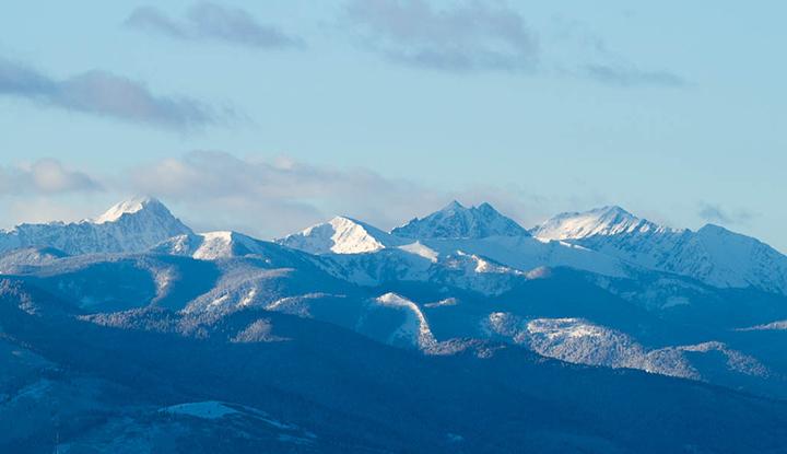
Gallatin Peak
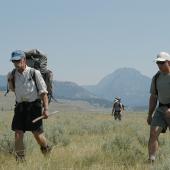
Hiking in the Spanish Peaks.
Gallatin Peak, at 11,015 feet, is the tallest of the Spanish Peaks south of Bozeman. While visible from town (it’s the one on the left), it is surprisingly isolated from civilization, with a clear view of its full span from top to bottom only available after many miles of trudging through the northernmost section of the Lee Metcalf Wilderness.
My brother Roger and I settled on Gallatin Peak while we were looking at a map for a nearby mountain to climb. We wanted one big enough that its ascent would rank as an actual accomplishment, yet still easy enough to be tackled by a couple of semiflabby amateurs. We decided to make a whole weekend backpacking trip out of our assault on the mountain, ambitiously taking on the 25-mile Indian Ridge loop starting from the Spanish Creek trailhead.
We started up Indian Ridge from Spanish Creek on a Friday afternoon in mid-July, hoping to cover the twelve miles to Thompson Lake at the base of Gallatin Peak before dark. Much of the first part crossed over Ted Turner’s infamous Flying D Ranch, a fact hard not to notice given the many signs warning us of the consequences of leaving the trail. We snickered at the graffiti (and worse) that had tarnished most of these signs. There’s nothing like the evidence of a good redneck shotgun blast at a "No Trespassing" sign to renew your faith in Montanans.
Since this was our first backpacking adventure in a number of years, Roger and I had loaded down our backpacks with all the gear we could think of, including enough food to feed a family for a week. In trying to be ready for every contingency we unfortunately had managed to make the hike as backbreaking as possible. We had forgotten that part of the thrill of backpacking is improvising with little instead of marveling at having lugged all the comforts of home into the backcountry.
After a grueling nine-mile hike, we set up camp just shy of Beacon Point. We reached Thompson Lake at the base of Gallatin Peak the next morning. From Thompson Lake the peak shot straight up another 2,000 feet. Our planned route to the top was the west face around the corner from the lake. A short but difficult scramble straight up a mossy slope into a massive cirque would be followed by a similar scramble to the summit via a near-vertical scree slope.
Upon reaching the spectacular, bowl-shaped cirque, we eagerly started up the nearest slope we could find. In testament to our nonexistent route-finding abilities, we eventually ran into near-vertical faces close to the summit. Thus the same choice popped up repeatedly: head straight up short vertical stretches, relying on bona fide rock-climbing; or shimmy down a bit and find an easier alternative with less exposure to the very real possibility of our untested rock-climbing skills failing at a crucial moment.
Depending on the circumstance, Roger and I did both, climbing over grotesquely steep rocks and chickening out on others. As we crested the summit ridge we found that the obvious route to the top was generally further to the south than the way we had come. While steep, this route was certainly not as life-threatening as the one we had chosen.
In due order we reached the summit. The view was of course indescribable. Bozeman was visible to the distant north, while the carved ski runs on Lone Mountain lay a short distance south. Up close were the rough-hewn rocks and ridges, forests and lakes of the Spanish Peaks.
With such a grand view, we took a moment to compose weighty thoughts for the register, a small metal box with a Forest Service emblem bolted to a convenient boulder. The notebook in the register only covered the past couple of years, but was nonetheless filled with the names of dozens of men and women of all ages from all over the country. Roger, cribbing from a nautical memorial he had seen in New England wrote, "Lord, your mountains are so big, and I am so small." Reflecting more appropriately on the task at hand, all I could come up with was "How do I get down?"
Gingerly stepping down the rocky scree face, we made our way back to the cirque. At one point the gravelly scree under my feet gave way and I found myself sliding farther and faster downhill than I would have liked. I became genuinely alarmed at whether I would be able to stop myself or whether this was the beginning of a short trip down the mountain to the afterlife. Scraping and clawing at larger, immobile boulders, I managed to arrest myself before my descent turned more serious.
Once down into the canyon, Roger and I gathered our packs and headed down Spanish Creek, past Summit Lake. We had planned to camp again, but with as much daylight as we had left we kept hoofing to the parking lot, a distance of roughly 13 miles downhill. We fired up Roger’s pickup at the trailhead just as the last vestiges of daylight disappeared. Back in Bozeman, I limped into bed, bruised, blistered, scratched, chafed, and as sore as I have ever been. After hiking and climbing 25 miles in a little less than a day and half, it hurt even to roll over. It was a great feeling.
45.366148859995, -111.36585237749