Getting There
Four-wheelin' in Flathead Pass.
Flex your frame, test your traction, and abuse your brakes on a road less traveled: Flathead Pass. This pass crosses the north end of the Bridger Mountains, and connects the Gallatin and Shields River valleys. The trail appears to have been etched-in with an east-west power transmission line, but likely traces a more primitive transit route.
High-clearance automobiles, ATVs, and dirt bikes commonly traverse this road. I've navigated it on foot, mountain bike, and in a Toyota SUV with 14 inches of ground clearance. I'm unwilling, however, to risk the undercarriage of my Ford Explorer. This is a narrow and rough jeep trail.
Late summer after the mud dries and early fall before the snow flies are ideal times to explore this route. In winter, consider a snowshoe, cross-country ski, or snowmobile trip over Flathead Pass.
From the 19th street exit of I-90 in Bozeman, head north on Springhill Road. The pavement ends after 11 miles as Springhill Road becomes Rocky Mountain Road. At mile 19 you’ll see the Flathead Pass Forest Service sign.
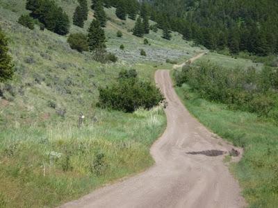
Heading east from there, the condition of the first mile of the road can vary widely. I've seen both graded, smooth gravel and foot-deep mud ruts. After the first mile, the trail narrows and begins to rise.
Expect inclined, twisting stretches with few turnaround opportunities for automobiles. Bedrock with gravel scree dominates the roadbed. You won’t see a house, and your cell phone will black out. Use caution, take a deep breath, and hold on!
From Rocky Mountain Road, the trail rises 1,700 feet over 3.2 miles to the summit of the Flathead Pass. Pass Creek serpentines alongside in abrupt banks that narrow the south edge of the trail. You'll see immense rock cliffs rising from the canyon walls. In summer, you'll likely encounter wildflowers, butterflies, and possibly biting flies. If traversing the pass in winter, be cautious. A skier died in an avalanche near the summit in 2001.
Although the west slope of this trail is a test, from the summit east it resembles nothing worse than an unimproved dirt washboard. Consider a side trip down one of the slender, scarcely used trails that furcate near the eastern summit.
To get back to Bozeman, continue down the east slope until you reach the pavement of Highway 86. Turn south, travel across Battle Ridge, pass by Bridger Bowl Ski Area, and you'll be back in Bozeman.
Always obey posted signs, stay on established trails, pack out everything that you bring in, and remember to tread lightly!