Local Trail Runs

Know what you're getting into.
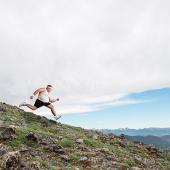
Bozeman has more than enough trails to keep its residents in shape. Whether you're training for your first half-marathon, for your fifth Ridge Run, or just for fun, there's a trail for that. Here are some local favorites to get started.
Sypes Canyon
Gorgeous, partly shady trail by a creek on the west side of the Bridgers. North 7th Street curves into West Frontage Road; go right at the light onto Springhill Road. North 1.5 miles to Sypes Canyon Road. Right 3.2 miles, right again to the trailhead parking area. Watch for kids on the trail; this is a popular family outing.
Trail distance: 4 miles out and back (if you turn around at the overlook)
Elevation gain: 1,000 feet
Sypes Canyon to the "M" parking lot
Ah, now we're talking fun! Take two cars out North Rouse, curve right onto Bridger Canyon Drive for 2.4 miles (4.2 from Main Street). The parking lot will be on the left, across from the Fish Hatchery. Leave a car here and don't forget your keys! Take the second car back to where North Rouse curved into Bridger Canyon Drive, and go right onto Griffin (before the Filling Station) to North 7th. Follow the directions to Sypes Canyon. Take the regular trail up Sypes. About a mile past the overlook two miles up, a small cairn marks the junction with the Bridger Foothills Trail (a.k.a., Bridger Mountain National Recreation Trail #534) to the "M." Turn right and enjoy the steep descent through rocks and trees. Not many people take this spot between the two trails, leaving the solitude intact. Dig in for a climb up and be rewarded with a soft trail through towering trees, opening onto a large slopeside meadow, and then a meandering sweep south to the parking lot.
Trail distance: 8 miles one way
Elevation gain: 2,000, adding the two uphill stretches together
South Cottonwood
The abundant, gentle trail. West Main toward Four Corners, left onto Cottonwood Road for 7.6 miles; another left onto Cottonwood Canyon Road. In 2.1 miles you'll be at the trailhead parking lot. There's a little climb at the start, but mostly you'll be running flat on soft dirt through trees, meadows, and by the creek. Watch for riders on horseback.
Trail distance: 3.2 miles round trip (turn around at second bridge), with extensions onto Langhor and History Rock Trails
Elevation gain: 250 feet
Kirk Hill
Great hill work; lots of trees; perfect for hot, sunny days. West Main left onto South 19th, south for 6.1 miles. Watch for the signage at the Kirk Hill parking lot on the left. One main trail leaves the parking lot; three loops are possible as you progress, with signs posted at the junctions. The trail is soft but steep and short, thus not used as much as others.
Trail distance: 1 to 3 miles
Elevation gain: 750 feet