On the Road
In Bozeman, truly remarkable landscapes are a fact of life. And, in my opinion, there is no better way to experience them than from the seat of a bike. So turn the “road trip” into a “bike trip”: take the camping stuff with you, reduce your carbon footprint, burn some calories, eat like a horse, and meet the locals. You’re one yourself.
This trip starts in West Yellowstone and passes south through the heart of Yellowstone and Grand Teton National Parks to Jackson, Wyoming. Come home by going up and over Teton Pass and down to Driggs, Idaho. From there, pedal north and catch the wonderfully quiet Mesa Falls Scenic Byway. An easy climb over Targhee Pass will bring you back to West Yellowstone.
It's simple and wonderfully efficient. Will it be challenging? Hopefully. Is it impossible? Not even remotely. Here's how my friend Todd and I did it.
DAY 1: West Yellowstone, MT to Lewis Lake Campground, YNP
Distance: approx. 58 miles
Highlights: Lower Geyser Basin and Old Faithful, Craig Pass, Yellowstone Lake, Free Heel & Wheel bike shop, swimming (naked and thus illegally in Yellowstone National Park), and cold beer.
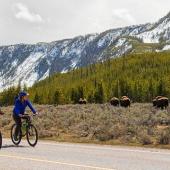
We start the trip by informing the West Yellowstone police of our plans and finding a quiet place to ditch Todd’s VW van. Loading up the bikes, Todd pulling a BOB cart and myself with panniers, we pedal immediately toward Free Heel & Wheel (West Yellowstone’s iconic combination bicycle and coffee shop) to load up on liquid caffeine and a few ground beans for the road. Then we head into the Park via the West Entrance. The road is smooth, has an adequate shoulder (for awhile anyway), and parallels the tranquil Madison River. And to anyone’s delight, you only have to share it with a few bison, a handful of elk, and several million park visitors, many of whom are attempting to maneuver oversized motor homes while chatting on cell phones, looking at the wildlife (not the road), and drinking coffee or, perhaps later in the day, a refreshing gin and tonic.
In the early afternoon, we stop at Lower Geyser Basin to see Old Faithful. The next scheduled eruption is posted on the wooden boardwalk, and literally thousands gather for, arguably, this most famous of Yellowstone’s features to blow. Which, almost like clockwork (hence the name), it does. And just as quick as it starts up, it's over and folks scram. They hit the road for the next attraction, because in fewer than 48 hours the average Park visitor can “see it all” from inside a car.
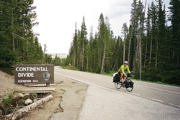
It's sad, because they could’ve joined us for a climb up and over Craig Pass (elevation 8,262 feet). On a clear day near the top, you can see the Tetons rising majestically to the south. We descend toward Yellowstone Lake and pull into Grant Village. Yellowstone Lake, cold and deep, has a serious afternoon wind-induced swell going on. Not too inviting for a swim. And so, recharged with milkshakes, bananas, and chocolate, we pedal onward for a gradual climb out of Grant Village and aim for the campground at Lewis Lake.
We pull into Lewis Lake with an hour of daylight remaining. The Park provides a certain number of hiker-biker campsites, so when it's time to quit for the day, there's always a place to pitch one’s tent. We find the place relatively quiet on this mid-July evening, but after dismounting, we begin to notice a whining noise—produced, it turns out, by the wings of millions of mosquitoes. They’re in our ears, our noses, our mouths, but as the sun settles to the west, their activity decreases. Headlamps aglow, we enjoy a dinner and cold beer (or two) on the public boat dock. And the final reward of the day: a swim, naked (and thus illegal), in Lewis Lake.
DAY 2: Lewis Lake Campground to Jackson, WY
Distance: approx. 75 miles
Highlights: Grand Teton National Park, swimming (again naked and illegally), the town of Jackson, and cold beer.
Most folks who have never ridden a touring bike loaded with a bunch of camping gear mistakenly assume that hills and mountain passes are the biggest challenge. But wind is the real nemesis. Strong headwinds can be, for lack of a better description, hell on wheels. Our ride into Grand Teton National Park and the gateway town of Jackson, Wyoming, is just such a day.
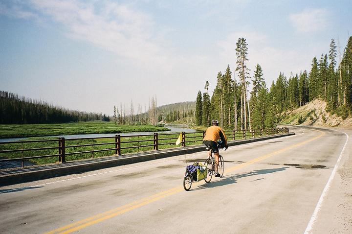
Up and out of the campground early, we cycle onto John D. Rockefeller Jr. Memorial Parkway, which starts just south of the Yellowstone Park boundary. Traffic is light, the way is mostly downhill, and the early morning light makes things especially photogenic.
But it's the end of the calm winds. Somewhere, just as we officially enter Grand Teton National Park, a stiff southerly wind kicks up. We see a string of women touring in the opposite direction. They look to be having a great time, and they look like they aren’t even pedaling! Todd and I on the other hand, are not moving much at all. The 50 remaining miles into Jackson, Wyoming, cost us time and, more significantly, energy. The miles go by very slowly.
But we don’t forget to look up every once in awhile. There, dominating the skyline to the west, is none other than Grand Teton. At 13,770 feet, it is the tallest mountain in the Teton Range. Use your imagination to figure out why a supposedly lonely French trapper named the peaks after a certain part of the female body.
To break the monotony of the wind, we go for a swim in Jackson Lake. The recent drought has lowered the water levels considerably, making access an issue. But we make it in and out, again naked and again illegally, enjoying time off the bikes. Somewhat reluctantly, we saddle up. Time to go.
We slowly pedal to Moose, Wyoming. No moose here today; perhaps they’re all down along the Snake River hiding from the wind. Just one more slow, barely moving hour and we make it into Jackson. The winds settle, our speed and spirits pick up, and before we know it we’re rolling into Jackson’s town square, which is famously dominated by arches of elk antlers. Like cowboys long out on the dusty trail, we find a nice campsite right in town, shower up, and hit the saloon(s). Bicycle touring makes one appreciate a soft pillow and a good night’s sleep.
DAY 3: Jackson to Mesa Falls Scenic Byway Campsite
Distance: approx. 77 miles
Highlights: tailwinds, paved bicycle route near Driggs, rolling countryside with potatoes, tailwinds, Mesa Falls Scenic Byway, and cold beer.
Gradient can occasionally play a significant, although generally short-lived, role in the day of a touring cyclist. Cycling out of Jackson, fresh bagels stowed away into panniers, we enjoy a flat few miles to Wilson. One more cup of coffee, a fill up of the water bottles, and then it’s up and over Teton Pass. At 8,429 feet, the pass is famous for its fantastic backcountry skiing, but the folks driving up with skis or snowboards likely don’t pay too much attention to a 10% gradient. Folks with loaded touring bikes do.
Eventually we find ourselves at the top. We get off the bikes, stretch, drink some water, and eat a banana. We take a picture or two. And we enjoy the great feeling of accomplishment that comes with pedaling a loaded touring bicycle up a mountain pass. After all, what took maybe an hour or two to climb will take us minutes to descend. It's not unheard of to hit 40 miles an hour going down a steep pass on a bicycle loaded with 30 pounds of gear.
Pedaling into Victor, Idaho, a delightful bicycle path connects Victor with its neighbor nine miles down the road, Driggs. Not that Idaho Route 33 is all that busy. We enjoy the large potato marking the drive-in theater, and see the Teton Range from the “other side.”
“Rolling” out of Driggs is exactly what happens. The landscape begins to roll. And fill with potatoes. The roller-coaster ride between Tetonia and Ashton is a pleasant change from the past several days, too. Farm machinery replaces the motor homes. Old pickups replace new rental cars. Older-model locals replace newer-model tourists. And that strong southerly wind is now in our favor. We cruise easily northward toward a small pub in Drummond to enjoy a cold PBR. Today, we have time to burn. The tailwinds have arrived!
Back on the road, just before Ashton, Idaho, we turn east onto Idaho Route 47. The road is marked with the “Mesa Falls Scenic Byway” sign. Smoothly paved, nice shoulders, closed during the winter—the Mesa Falls Scenic Byway is a touring cyclist's dream come true. Several primitive (always the best) campgrounds are along the route, and we enjoy views of both the Lower and Upper Falls (the latter over 114 feet high) as we climb onto the Yellowstone plateau. Be warned about the traffic—nary a car in sight! And swimming naked—it’s once again illegal. I think.
DAY 4: Mesa Falls Scenic Byway to West Yellowstone
Distance: approx. 48 miles
Highlights: tailwinds, philosophical contemplation, and cold beer
The last half of the Mesa Falls Scenic Byway is as attractive as the first: scenic, quiet, and apparently rarely utilized by cars. We connect with U.S. Route 20 just south of Island Park. Traffic picks up noticeably, but the shoulders are adequate and thankfully they have yet to be “rumble stripped” (don’t get me started on that sour issue).
Strong southerly tailwinds, our enemy several days ago, now push us quickly northward. Now we, like the “flying ladies” last seen heading northward in Wyoming, are moving with ease. We’re pedaling along at 20-25 miles per hour. Before we know it, we’re back home.
“Welcome to Montana” announces the distinctive blue sign perched atop the 7,072-foot summit of Targhee Pass. Todd is way out in front, at least a mile away, and pedaling hard for West Yellowstone. Perhaps he’s in a hurry to get back to Free Heel & Wheel for some anticipated treat. As for myself, I want to slow things down and enjoy the moment.
That’s the point of it all. You will not do well bike touring if you keep thinking about things waiting at home. If you don’t live in the moment, you’ll be lost in the future. As I ride into West Yellowstone, I’m grateful for the past four days and am just now starting to think about things yet to come: those cold beers waiting in the cooler of Todd’s van. Shoot, maybe that’s why he was in such a hurry.